Property Information
mobile view
| Serial Number: 08:141:0018 |
Serial Life: 2009... |
|
|
Total Photos: 3
|
| |
|
|
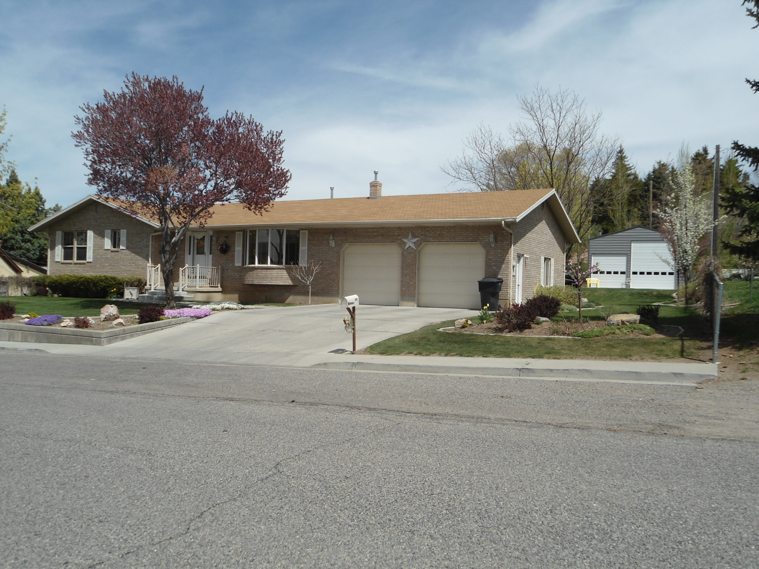
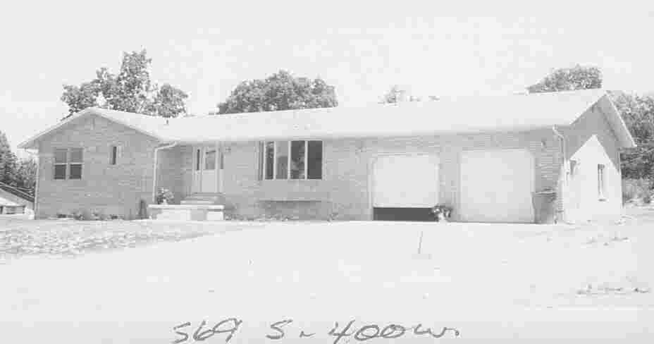
| Property Address: 569 S 400 WEST - PAYSON |
|
| Mailing Address: 569 S 400 W PAYSON, UT 84651-2701 |
|
| Acreage: 0.53688 |
|
| Last Document:
18068-2008
|
|
| Subdivision Map Filing |
|
| Taxing Description:
COM N 82.5 FT FR SW COR. LOT 2, BLK. 31, PLAT P, PAYSON CITY SURVEY; N 110 FT; E 145 FT; S 3 FT; E 69.5 FT; S 107 FT; W 214.5 FT TO BEG. AREA 0.537 AC.
*Taxing description NOT FOR LEGAL DOCUMENTS
|
|
- Owner Names
- Value History
- Tax History
- Location
- Photos
- Documents
- Aerial Image
| |
----- Real Estate Values ----- |
---Improvements--- |
---Greenbelt--- |
Total |
| Year |
Com |
Res |
Agr |
Tot |
Com |
Res |
Agr |
Tot |
Land |
Homesite |
Tot |
Market Value |
| 2024 |
$0 |
$129,300 |
$0 |
$129,300 |
$0 |
$329,400 |
$0 |
$329,400 |
$0 |
$0 |
$0 |
$458,700 |
| 2023 |
$0 |
$129,300 |
$0 |
$129,300 |
$0 |
$328,300 |
$0 |
$328,300 |
$0 |
$0 |
$0 |
$457,600 |
| 2022 |
$0 |
$137,900 |
$0 |
$137,900 |
$0 |
$292,700 |
$0 |
$292,700 |
$0 |
$0 |
$0 |
$430,600 |
| 2021 |
$0 |
$110,300 |
$0 |
$110,300 |
$0 |
$206,100 |
$0 |
$206,100 |
$0 |
$0 |
$0 |
$316,400 |
| 2020 |
$0 |
$95,900 |
$0 |
$95,900 |
$0 |
$193,000 |
$0 |
$193,000 |
$0 |
$0 |
$0 |
$288,900 |
| 2019 |
$0 |
$82,900 |
$0 |
$82,900 |
$0 |
$193,000 |
$0 |
$193,000 |
$0 |
$0 |
$0 |
$275,900 |
| 2018 |
$0 |
$69,800 |
$0 |
$69,800 |
$0 |
$167,800 |
$0 |
$167,800 |
$0 |
$0 |
$0 |
$237,600 |
| 2017 |
$0 |
$67,200 |
$0 |
$67,200 |
$0 |
$145,900 |
$0 |
$145,900 |
$0 |
$0 |
$0 |
$213,100 |
| 2016 |
$0 |
$61,000 |
$0 |
$61,000 |
$0 |
$145,900 |
$0 |
$145,900 |
$0 |
$0 |
$0 |
$206,900 |
| 2015 |
$0 |
$56,700 |
$0 |
$56,700 |
$0 |
$126,900 |
$0 |
$126,900 |
$0 |
$0 |
$0 |
$183,600 |
| 2014 |
$0 |
$52,300 |
$0 |
$52,300 |
$0 |
$114,900 |
$0 |
$114,900 |
$0 |
$0 |
$0 |
$167,200 |
| 2013 |
$0 |
$42,600 |
$0 |
$42,600 |
$0 |
$114,900 |
$0 |
$114,900 |
$0 |
$0 |
$0 |
$157,500 |
| 2012 |
$0 |
$44,300 |
$0 |
$44,300 |
$0 |
$130,500 |
$0 |
$130,500 |
$0 |
$0 |
$0 |
$174,800 |
| 2011 |
$0 |
$45,700 |
$0 |
$45,700 |
$0 |
$135,500 |
$0 |
$135,500 |
$0 |
$0 |
$0 |
$181,200 |
| 2010 |
$0 |
$50,414 |
$0 |
$50,414 |
$0 |
$142,121 |
$0 |
$142,121 |
$0 |
$0 |
$0 |
$192,535 |
| 2009 |
$0 |
$69,800 |
$0 |
$69,800 |
$0 |
$135,200 |
$0 |
$135,200 |
$0 |
$0 |
$0 |
$205,000 |
| Year |
General Taxes |
Adjustments |
Net Taxes |
Fees |
Payments |
Tax Balance* |
Balance Due |
Tax District |
| 2025 |
$0.00 |
$0.00 |
$0.00 |
$0.00 |
|
$0.00
|
$0.00 |
170 - PAYSON CITY |
| 2024 |
$0.00 |
$0.00 |
$0.00 |
$0.00 |
|
$0.00
|
$0.00 |
170 - PAYSON CITY |
| 2023 |
$2,466.21 |
$0.00 |
$2,466.21 |
$0.00 |
|
$0.00
|
$0.00 |
170 - PAYSON CITY |
| 2022 |
$2,359.54 |
$0.00 |
$2,359.54 |
$0.00 |
|
$0.00
|
$0.00 |
170 - PAYSON CITY |
| 2021 |
$1,965.38 |
$0.00 |
$1,965.38 |
$0.00 |
|
$0.00
|
$0.00 |
170 - PAYSON CITY |
| 2020 |
$1,834.28 |
$0.00 |
$1,834.28 |
$0.00 |
|
$0.00
|
$0.00 |
170 - PAYSON CITY |
| 2019 |
$1,708.65 |
$0.00 |
$1,708.65 |
$0.00 |
|
$0.00
|
$0.00 |
170 - PAYSON CITY |
| 2018 |
$1,526.73 |
$0.00 |
$1,526.73 |
$0.00 |
|
$0.00
|
$0.00 |
170 - PAYSON CITY |
| 2017 |
$1,400.25 |
$0.00 |
$1,400.25 |
$0.00 |
|
$0.00
|
$0.00 |
170 - PAYSON CITY |
| 2016 |
$1,368.50 |
$0.00 |
$1,368.50 |
$0.00 |
|
$0.00
|
$0.00 |
170 - PAYSON CITY |
| 2015 |
$1,222.77 |
$0.00 |
$1,222.77 |
$0.00 |
|
$0.00
|
$0.00 |
170 - PAYSON CITY |
| 2014 |
$1,105.54 |
$0.00 |
$1,105.54 |
$0.00 |
|
$0.00
|
$0.00 |
170 - PAYSON CITY |
| 2013 |
$1,090.09 |
$0.00 |
$1,090.09 |
$0.00 |
|
$0.00
|
$0.00 |
170 - PAYSON CITY |
| 2012 |
$1,228.09 |
$0.00 |
$1,228.09 |
$0.00 |
|
$0.00
|
$0.00 |
170 - PAYSON CITY |
| 2011 |
$1,242.86 |
$0.00 |
$1,242.86 |
$0.00 |
|
$0.00
|
$0.00 |
170 - PAYSON CITY |
| 2010 |
$1,287.68 |
$0.00 |
$1,287.68 |
$0.00 |
|
$0.00
|
$0.00 |
170 - PAYSON CITY |
| 2009 |
$1,298.54 |
($1.80) |
$1,296.74 |
$0.00 |
|
$0.00
|
$0.00 |
170 - PAYSON CITY |
* Note: Original tax amount (Does not include applicable interest and/or fees).
| Entry # |
Date |
Recorded |
Type |
Party1 (Grantor) |
Party2 (Grantee) |
| 145665-2020 |
09/23/2020 |
09/23/2020 |
REC |
ALTABANK TEE |
PETERSON, MAX L & DIANA |
| 139046-2020 |
09/08/2020 |
09/14/2020 |
D TR |
PETERSON, MAX L & DIANA |
ALTABANK |
| 3187-2015 |
12/04/2014 |
01/14/2015 |
QCD |
UNITED STATES OF AMERICA |
SOUTH UTAH VALLEY ELECTRIC SERVICE DISTRICT |
| 58887-2010 |
07/15/2010 |
07/16/2010 |
MOD AGR |
PETERSON, MAX L & DIANA |
BANK OF AMERICAN FORK |
| 114949-2008 |
10/20/2008 |
10/22/2008 |
CT |
STATE OF UTAH |
WHOM OF INTEREST |
| 107508-2008 |
09/30/2008 |
09/30/2008 |
RESOL |
BOARD OF COUNTY COMMISSIONERS UTAH COUNTY |
WHOM OF INTEREST |
| 58257-2008 |
05/12/2008 |
05/16/2008 |
MOD AGR |
PETERSON, MAX L & DIANA |
BANK OF AMERICAN FORK |
| 18068-2008 |
10/06/2006 |
02/15/2008 |
QCD |
PETERSON, MAX L & DIANA |
SANFORD, RICHARD T & ESTER E TEE |
Main Menu Comments or Concerns on Value/Appraisal - Assessor's Office
Documents/Owner/Parcel information - Recorder's Office
Address Change for Tax Notice
This page was created on 5/20/2024 6:47:30 AM |
