Property Information
mobile view
| Serial Number: 08:118:0022 |
Serial Life: 2012... |
|
|
Total Photos: 3
|
| |
|
|
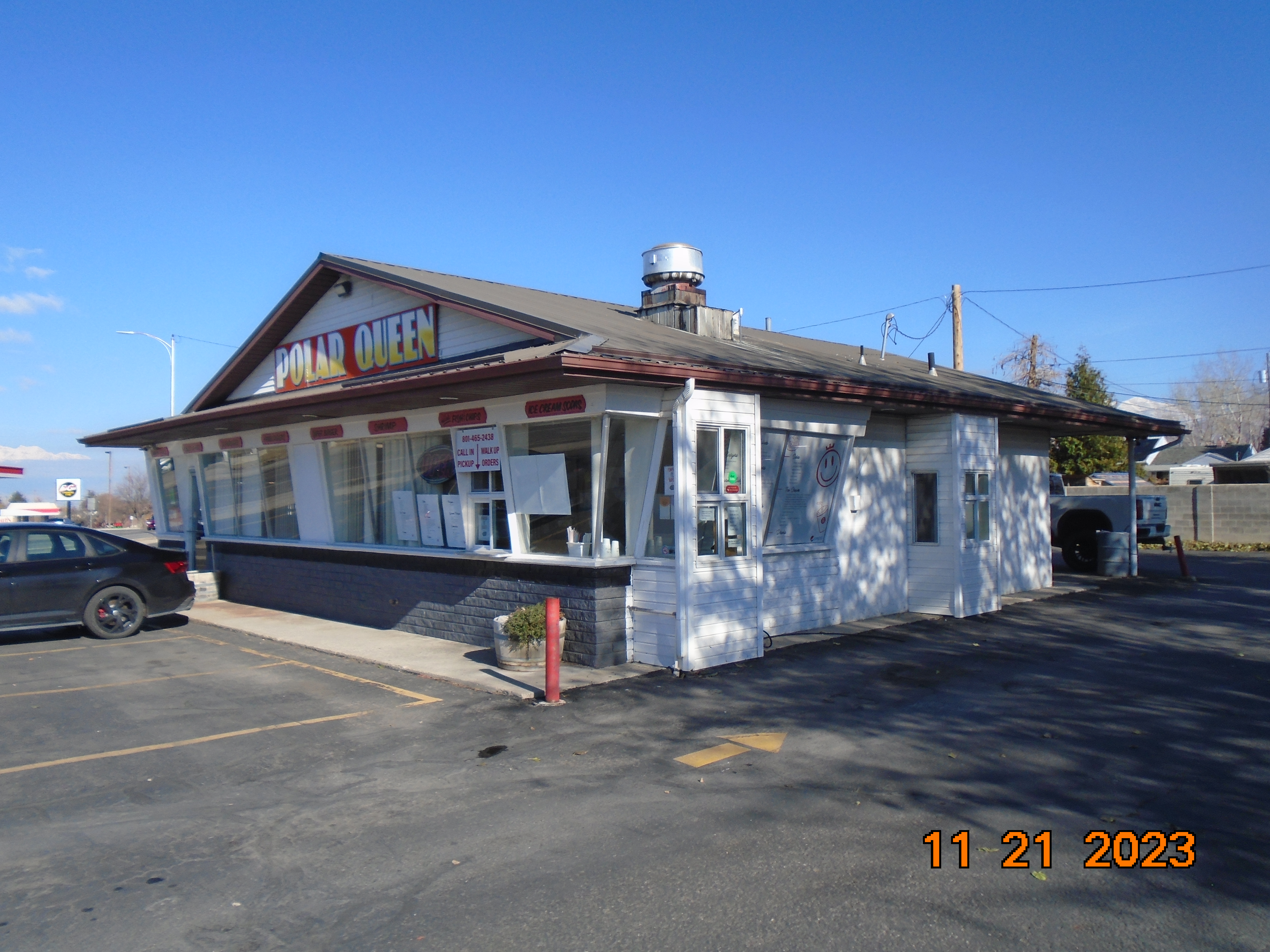
| Property Address: 745 S HWY 198 - PAYSON |
|
| Mailing Address: 858 E 600 S SANTAQUIN, UT 84655 |
|
| Acreage: 0.457914 |
|
| Last Document:
196913-2020
|
|
| Subdivision Map Filing |
|
| Taxing Description:
COM N 140 FT & W 130 FT & N 59 FT FR SE COR. BLK. 8, PLAT P, PAYSON CITY SURVEY; W 82 FT; N 31 DEG 30' 0" W 75 FT; N 42 DEG 25' 55" E 124 FT (RECORD: NE'LY 110 FT M OR L); S 45 DEG 0' 0" E 70 FT (RECORD: SE'LY 70 FT); S 106 FT; W 12 FT TO BEG. AREA 0.330 AC. ALSO COM S 177 FT & N 79 DEG 0' 0" W 78.7 FT FR NE COR. BLK. 8, PLAT P, PAYSON CITY SURVEY; S 23 DEG 30' 0" W 83.8 FT; S 1 DEG 30' 0" W 51 FT; W 5.8 FT; N 20 FT; N 45 DEG 22' 26" W 68.39 FT; ALONG A CURVE TO L (CHORD BEARS: N 33 DEG 59' 2" E 100.09 FT, RADIUS = 1555 FT); S 55 DEG 6' 36" E 40.57 FT TO BEG. AREA 0.127 AC. TOTAL AREA .458 AC.
*Taxing description NOT FOR LEGAL DOCUMENTS
|
|
- Owner Names
- Value History
- Tax History
- Location
- Photos
- Documents
- Aerial Image
| |
----- Real Estate Values ----- |
---Improvements--- |
---Greenbelt--- |
Total |
| Year |
Com |
Res |
Agr |
Tot |
Com |
Res |
Agr |
Tot |
Land |
Homesite |
Tot |
Market Value |
| 2024 |
$224,300 |
$0 |
$0 |
$224,300 |
$166,300 |
$0 |
$0 |
$166,300 |
$0 |
$0 |
$0 |
$390,600 |
| 2023 |
$221,900 |
$0 |
$0 |
$221,900 |
$182,600 |
$0 |
$0 |
$182,600 |
$0 |
$0 |
$0 |
$404,500 |
| 2022 |
$221,900 |
$0 |
$0 |
$221,900 |
$185,600 |
$0 |
$0 |
$185,600 |
$0 |
$0 |
$0 |
$407,500 |
| 2021 |
$194,700 |
$0 |
$0 |
$194,700 |
$192,400 |
$0 |
$0 |
$192,400 |
$0 |
$0 |
$0 |
$387,100 |
| 2020 |
$194,700 |
$0 |
$0 |
$194,700 |
$174,000 |
$0 |
$0 |
$174,000 |
$0 |
$0 |
$0 |
$368,700 |
| 2019 |
$177,000 |
$0 |
$0 |
$177,000 |
$177,300 |
$0 |
$0 |
$177,300 |
$0 |
$0 |
$0 |
$354,300 |
| 2018 |
$141,200 |
$0 |
$0 |
$141,200 |
$129,500 |
$0 |
$0 |
$129,500 |
$0 |
$0 |
$0 |
$270,700 |
| 2017 |
$135,800 |
$0 |
$0 |
$135,800 |
$129,500 |
$0 |
$0 |
$129,500 |
$0 |
$0 |
$0 |
$265,300 |
| 2016 |
$129,500 |
$0 |
$0 |
$129,500 |
$129,500 |
$0 |
$0 |
$129,500 |
$0 |
$0 |
$0 |
$259,000 |
| 2015 |
$125,300 |
$0 |
$0 |
$125,300 |
$129,500 |
$0 |
$0 |
$129,500 |
$0 |
$0 |
$0 |
$254,800 |
| 2014 |
$121,100 |
$0 |
$0 |
$121,100 |
$129,500 |
$0 |
$0 |
$129,500 |
$0 |
$0 |
$0 |
$250,600 |
| 2013 |
$113,200 |
$0 |
$0 |
$113,200 |
$129,500 |
$0 |
$0 |
$129,500 |
$0 |
$0 |
$0 |
$242,700 |
| 2012 |
$113,200 |
$0 |
$0 |
$113,200 |
$129,500 |
$0 |
$0 |
$129,500 |
$0 |
$0 |
$0 |
$242,700 |
| Year |
General Taxes |
Adjustments |
Net Taxes |
Fees |
Payments |
Tax Balance* |
Balance Due |
Tax District |
| 2025 |
$0.00 |
$0.00 |
$0.00 |
$0.00 |
|
$0.00
|
$0.00 |
170 - PAYSON CITY |
| 2024 |
$0.00 |
$0.00 |
$0.00 |
$0.00 |
|
$0.00
|
$0.00 |
170 - PAYSON CITY |
| 2023 |
$3,963.70 |
$0.00 |
$3,963.70 |
$0.00 |
|
$0.00
|
$0.00 |
170 - PAYSON CITY |
| 2022 |
$4,059.92 |
$0.00 |
$4,059.92 |
$0.00 |
|
$0.00
|
$0.00 |
170 - PAYSON CITY |
| 2021 |
$4,371.91 |
$0.00 |
$4,371.91 |
$0.00 |
|
$0.00
|
$0.00 |
170 - PAYSON CITY |
| 2020 |
$4,256.27 |
$0.00 |
$4,256.27 |
$0.00 |
|
$0.00
|
$0.00 |
170 - PAYSON CITY |
| 2019 |
$3,989.42 |
$0.00 |
$3,989.42 |
$0.00 |
|
$0.00
|
$0.00 |
170 - PAYSON CITY |
| 2018 |
$3,162.59 |
$0.00 |
$3,162.59 |
$0.00 |
|
$0.00
|
$0.00 |
170 - PAYSON CITY |
| 2017 |
$3,169.54 |
$0.00 |
$3,169.54 |
$0.00 |
|
$0.00
|
$0.00 |
170 - PAYSON CITY |
| 2016 |
$3,114.73 |
$0.00 |
$3,114.73 |
$0.00 |
|
$0.00
|
$0.00 |
170 - PAYSON CITY |
| 2015 |
$3,085.37 |
$0.00 |
$3,085.37 |
$0.00 |
|
$0.00
|
$0.00 |
170 - PAYSON CITY |
| 2014 |
$3,012.71 |
$0.00 |
$3,012.71 |
$0.00 |
|
$0.00
|
$0.00 |
170 - PAYSON CITY |
| 2013 |
$3,054.14 |
$0.00 |
$3,054.14 |
$0.00 |
|
$0.00
|
$0.00 |
170 - PAYSON CITY |
| 2012 |
$3,100.25 |
$0.00 |
$3,100.25 |
$0.00 |
|
$0.00
|
$0.00 |
170 - PAYSON CITY |
* Note: Original tax amount (Does not include applicable interest and/or fees).
| Entry # |
Date |
Recorded |
Type |
Party1 (Grantor) |
Party2 (Grantee) |
| 196913-2020 |
12/09/2020 |
12/10/2020 |
QCD |
FRIXIONE, GLENDA B |
FRIXIONE, GLENDA B TEE (ET AL) |
| 196912-2020 |
12/09/2020 |
12/10/2020 |
AF DC |
FRIXIONE, AMADEO OSCAR & AMADEO O AKA |
WHOM OF INTEREST |
| 3187-2015 |
12/04/2014 |
01/14/2015 |
QCD |
UNITED STATES OF AMERICA |
SOUTH UTAH VALLEY ELECTRIC SERVICE DISTRICT |
| 67757-2011 |
09/26/2011 |
09/26/2011 |
QCD |
FRIXIONE, AMADEO O & GLENDA B |
FRIXIONE, AMADEO OSCAR & GLENDA B |
Main Menu Comments or Concerns on Value/Appraisal - Assessor's Office
Documents/Owner/Parcel information - Recorder's Office
Address Change for Tax Notice
This page was created on 5/20/2024 9:14:06 AM |

