Property Information
mobile view
| Serial Number: 46:639:0002 |
Serial Life: 2005... |
|
|
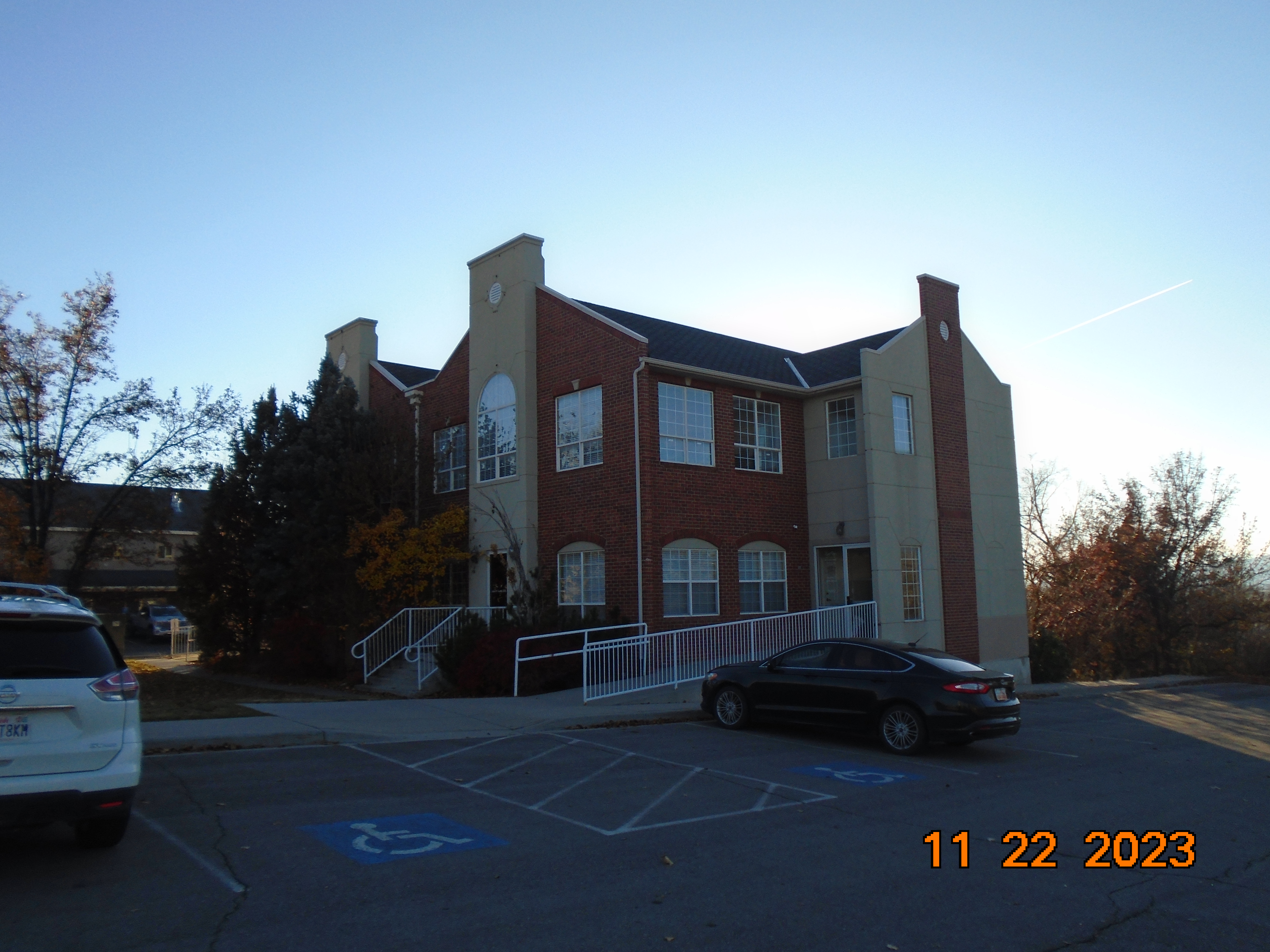
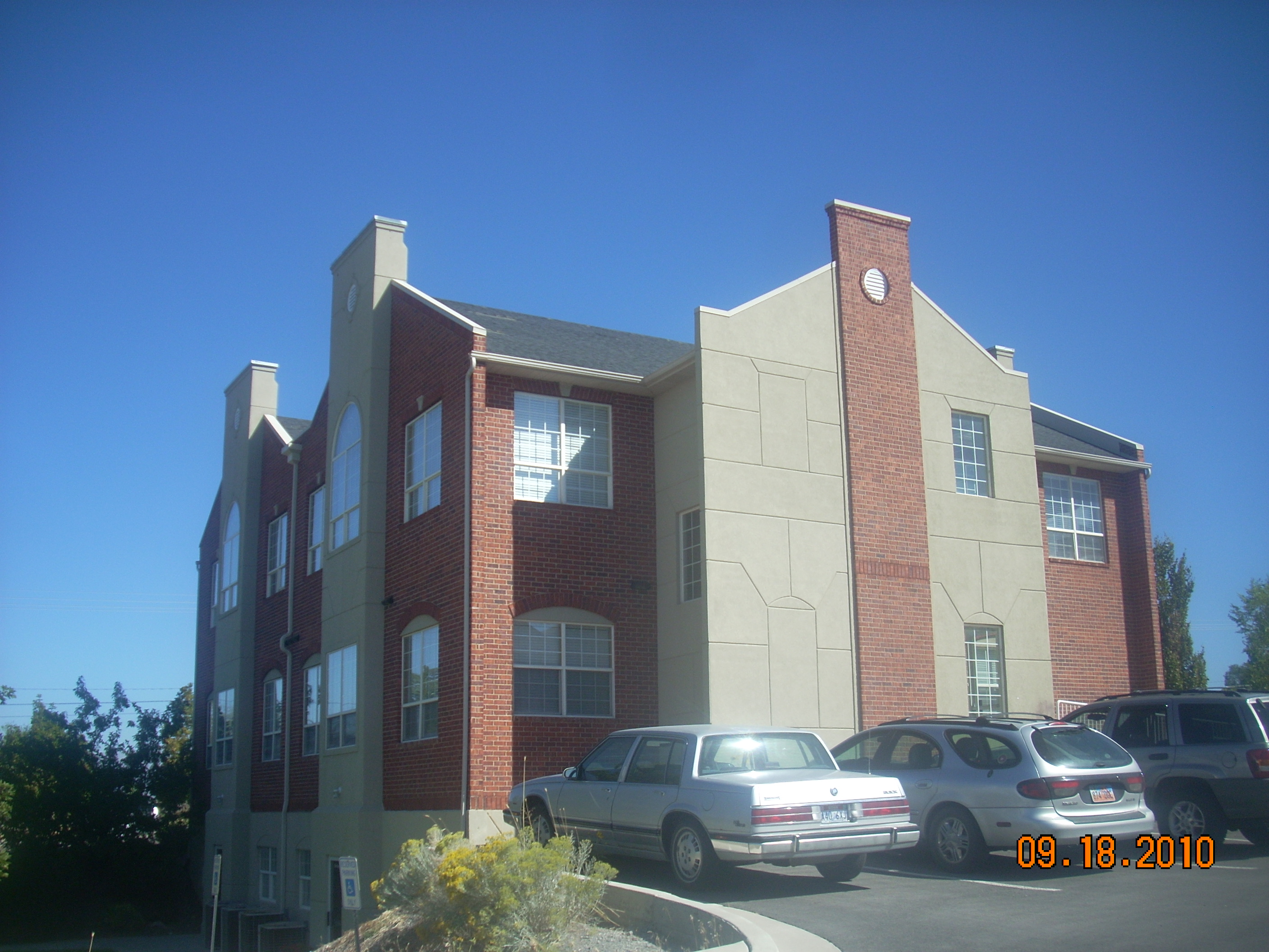
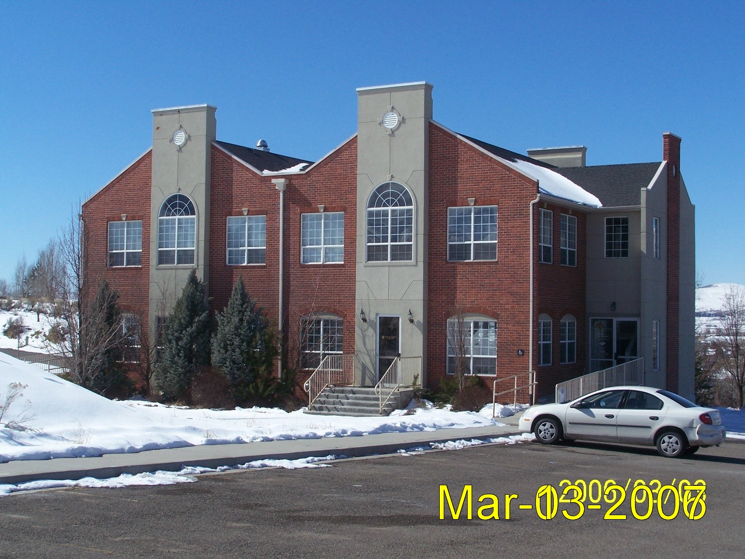
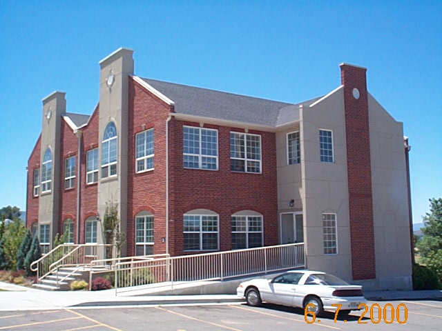
Total Photos: 6
|
| |
|
|
| Property Address: 805 S 500 WEST - PAYSON |
|
| Mailing Address: 805 S 500 W # 10 PAYSON, UT 84651 |
|
| Acreage: 5.77 |
|
| Last Document:
8463-2006
|
|
| Subdivision Map Filing |
|
| Taxing Description:
LOT 2, MILLRIDGE SUBDV. AREA 5.770 AC.
*Taxing description NOT FOR LEGAL DOCUMENTS
|
|
- Owner Names
- Value History
- Tax History
- Location
- Photos
- Documents
- Aerial Image
| |
----- Real Estate Values ----- |
---Improvements--- |
---Greenbelt--- |
Total |
| Year |
Com |
Res |
Agr |
Tot |
Com |
Res |
Agr |
Tot |
Land |
Homesite |
Tot |
Market Value |
| 2024 |
$1,557,200 |
$0 |
$0 |
$1,557,200 |
$1,243,100 |
$0 |
$0 |
$1,243,100 |
$0 |
$0 |
$0 |
$2,800,300 |
| 2023 |
$1,495,200 |
$0 |
$0 |
$1,495,200 |
$1,271,600 |
$0 |
$0 |
$1,271,600 |
$0 |
$0 |
$0 |
$2,766,800 |
| 2022 |
$1,495,200 |
$0 |
$0 |
$1,495,200 |
$1,100,100 |
$0 |
$0 |
$1,100,100 |
$0 |
$0 |
$0 |
$2,595,300 |
| 2021 |
$1,470,300 |
$0 |
$0 |
$1,470,300 |
$683,300 |
$0 |
$0 |
$683,300 |
$0 |
$0 |
$0 |
$2,153,600 |
| 2020 |
$1,470,300 |
$0 |
$0 |
$1,470,300 |
$749,900 |
$0 |
$0 |
$749,900 |
$0 |
$0 |
$0 |
$2,220,200 |
| 2019 |
$1,336,700 |
$0 |
$0 |
$1,336,700 |
$749,900 |
$0 |
$0 |
$749,900 |
$0 |
$0 |
$0 |
$2,086,600 |
| 2018 |
$1,231,600 |
$0 |
$0 |
$1,231,600 |
$742,800 |
$0 |
$0 |
$742,800 |
$0 |
$0 |
$0 |
$1,974,400 |
| 2017 |
$1,186,300 |
$0 |
$0 |
$1,186,300 |
$726,600 |
$0 |
$0 |
$726,600 |
$0 |
$0 |
$0 |
$1,912,900 |
| 2016 |
$1,131,000 |
$0 |
$0 |
$1,131,000 |
$729,900 |
$0 |
$0 |
$729,900 |
$0 |
$0 |
$0 |
$1,860,900 |
| 2015 |
$1,093,300 |
$0 |
$0 |
$1,093,300 |
$670,100 |
$0 |
$0 |
$670,100 |
$0 |
$0 |
$0 |
$1,763,400 |
| 2014 |
$1,058,600 |
$0 |
$0 |
$1,058,600 |
$670,100 |
$0 |
$0 |
$670,100 |
$0 |
$0 |
$0 |
$1,728,700 |
| 2013 |
$989,300 |
$0 |
$0 |
$989,300 |
$670,100 |
$0 |
$0 |
$670,100 |
$0 |
$0 |
$0 |
$1,659,400 |
| 2012 |
$989,300 |
$0 |
$0 |
$989,300 |
$693,900 |
$0 |
$0 |
$693,900 |
$0 |
$0 |
$0 |
$1,683,200 |
| 2011 |
$989,300 |
$0 |
$0 |
$989,300 |
$693,900 |
$0 |
$0 |
$693,900 |
$0 |
$0 |
$0 |
$1,683,200 |
| 2010 |
$863,282 |
$0 |
$0 |
$863,282 |
$752,184 |
$0 |
$0 |
$752,184 |
$0 |
$0 |
$0 |
$1,615,466 |
| 2009 |
$880,900 |
$0 |
$0 |
$880,900 |
$808,800 |
$0 |
$0 |
$808,800 |
$0 |
$0 |
$0 |
$1,689,700 |
| 2008 |
$779,200 |
$0 |
$0 |
$779,200 |
$1,004,500 |
$0 |
$0 |
$1,004,500 |
$0 |
$0 |
$0 |
$1,783,700 |
| 2007 |
$742,100 |
$0 |
$0 |
$742,100 |
$956,700 |
$0 |
$0 |
$956,700 |
$0 |
$0 |
$0 |
$1,698,800 |
| 2006 |
$618,400 |
$0 |
$0 |
$618,400 |
$869,717 |
$0 |
$0 |
$869,717 |
$0 |
$0 |
$0 |
$1,488,117 |
| 2005 |
$618,400 |
$0 |
$0 |
$618,400 |
$869,717 |
$0 |
$0 |
$869,717 |
$0 |
$0 |
$0 |
$1,488,117 |
| Year |
General Taxes |
Adjustments |
Net Taxes |
Fees |
Payments |
Tax Balance* |
Balance Due |
Tax District |
| 2025 |
$0.00 |
$0.00 |
$0.00 |
$0.00 |
|
$0.00
|
$0.00 |
170 - PAYSON CITY |
| 2024 |
$0.00 |
$0.00 |
$0.00 |
$0.00 |
|
$0.00
|
$0.00 |
170 - PAYSON CITY |
| 2023 |
$27,111.87 |
$0.00 |
$27,111.87 |
$0.00 |
|
$0.00
|
$0.00 |
170 - PAYSON CITY |
| 2022 |
$25,856.97 |
$0.00 |
$25,856.97 |
$0.00 |
|
$0.00
|
$0.00 |
170 - PAYSON CITY |
| 2021 |
$24,322.76 |
$0.00 |
$24,322.76 |
$0.00 |
|
$0.00
|
$0.00 |
170 - PAYSON CITY |
| 2020 |
$25,629.99 |
$0.00 |
$25,629.99 |
$0.00 |
|
$0.00
|
$0.00 |
170 - PAYSON CITY |
| 2019 |
$23,495.12 |
$0.00 |
$23,495.12 |
$0.00 |
|
$0.00
|
$0.00 |
170 - PAYSON CITY |
| 2018 |
$23,066.92 |
$0.00 |
$23,066.92 |
$0.00 |
|
$0.00
|
$0.00 |
170 - PAYSON CITY |
| 2017 |
$22,853.42 |
$0.00 |
$22,853.42 |
$0.00 |
|
$0.00
|
$0.00 |
170 - PAYSON CITY |
| 2016 |
$22,379.18 |
$0.00 |
$22,379.18 |
$0.00 |
|
$0.00
|
$0.00 |
170 - PAYSON CITY |
| 2015 |
$21,353.01 |
$0.00 |
$21,353.01 |
$0.00 |
|
$0.00
|
$0.00 |
170 - PAYSON CITY |
| 2014 |
$20,782.43 |
$0.00 |
$20,782.43 |
$0.00 |
|
$0.00
|
$0.00 |
170 - PAYSON CITY |
| 2013 |
$20,881.89 |
$0.00 |
$20,881.89 |
$0.00 |
|
$0.00
|
$0.00 |
170 - PAYSON CITY |
| 2012 |
$21,501.20 |
$0.00 |
$21,501.20 |
$0.00 |
|
$0.00
|
$0.00 |
170 - PAYSON CITY |
| 2011 |
$20,991.19 |
$0.00 |
$20,991.19 |
$0.00 |
|
$0.00
|
$0.00 |
170 - PAYSON CITY |
| 2010 |
$19,644.07 |
$0.00 |
$19,644.07 |
$0.00 |
|
$0.00
|
$0.00 |
170 - PAYSON CITY |
| 2009 |
$19,460.27 |
$0.00 |
$19,460.27 |
$0.00 |
|
$0.00
|
$0.00 |
170 - PAYSON CITY |
| 2008 |
$19,108.78 |
$0.00 |
$19,108.78 |
$0.00 |
|
$0.00
|
$0.00 |
170 - PAYSON CITY |
| 2007 |
$18,051.45 |
$0.00 |
$18,051.45 |
$0.00 |
|
$0.00
|
$0.00 |
170 - PAYSON CITY |
| 2006 |
$17,570.20 |
$0.00 |
$17,570.20 |
$0.00 |
|
$0.00
|
$0.00 |
170 - PAYSON CITY |
| 2005 |
$18,704.14 |
$0.00 |
$18,704.14 |
$0.00 |
|
$0.00
|
$0.00 |
170 - PAYSON CITY |
* Note: Original tax amount (Does not include applicable interest and/or fees).
| Entry # |
Date |
Recorded |
Type |
Party1 (Grantor) |
Party2 (Grantee) |
| 17961-2015 |
02/18/2015 |
03/05/2015 |
REC |
CENTRAL BANK TEE |
JMF OFFICE LLC |
| 3187-2015 |
12/04/2014 |
01/14/2015 |
QCD |
UNITED STATES OF AMERICA |
SOUTH UTAH VALLEY ELECTRIC SERVICE DISTRICT |
| 24729-2012 |
03/08/2012 |
03/28/2012 |
REC |
BANK OF AMERICAN FORK TEE |
JOHN M FARLEY PROPERTIES LC |
| 14488-2012 |
02/23/2012 |
02/24/2012 |
D TR |
JMF OFFICE LLC |
CENTRAL BANK |
| 114949-2008 |
10/20/2008 |
10/22/2008 |
CT |
STATE OF UTAH |
WHOM OF INTEREST |
| 107508-2008 |
09/30/2008 |
09/30/2008 |
RESOL |
BOARD OF COUNTY COMMISSIONERS UTAH COUNTY |
WHOM OF INTEREST |
| 8463-2006 |
01/09/2006 |
01/24/2006 |
WD |
JOHN M FARLEY PROPERTIES LLC |
JMF OFFICE LLC |
| 94446-2004 |
07/29/2004 |
08/17/2004 |
AGR |
FARLEY, JOHN (ET AL) |
PAYSON CITY |
| 94445-2004 |
08/04/2004 |
08/17/2004 |
S PLAT |
JOHN M FARLEY PROPERTIES LC |
MILLRIDGE |
Main Menu Comments or Concerns on Value/Appraisal - Assessor's Office
Documents/Owner/Parcel information - Recorder's Office
Address Change for Tax Notice
This page was created on 5/20/2024 10:35:17 AM |

